Great Northern Filing Map, Browning, Montana, 1909
- US MnSpGNR E0477-003-012-002-EBP0452
- Item
- 1909
Great Northern Blueprint Number 1248-15-1, map of land required for Reservoir, 1909. Other subject categories: Filing Map
8 results directly related Exclude narrower terms
Great Northern Filing Map, Browning, Montana, 1909
Great Northern Blueprint Number 1248-15-1, map of land required for Reservoir, 1909. Other subject categories: Filing Map
Great Northern Filing Map, Browning, Montana, 1910
Great Northern Blueprint Number 1248-15-2, map of Reservoir and Pipe Line, 1910. Other subject categories: Filing Map
Great Northern Filing Map, Browning, Montana, 1918
Great Northern Blueprint Number 1248-15-6, map of more land for Station, 1918. Other subject categories: Filing Map
Great Northern Filing Map, Browning, Montana, 1966
Great Northern Blueprint Number 1248-15-7, map of tract at Browning, 1966. Other subject categories: Filing Map
Great Northern Filing Map, Browning, Montana, 1967
Great Northern Blueprint Number 1248-15-8, map of tract 3/4 Mile West of Browning, 1967. Other subject categories: Filing Map
Great Northern Filing Map, Browning, Montana, undated
Great Northern Blueprint Number 1248-15-5, map of more land for Station, undated. Other subject categories: Filing Map
Plat Map of Great Northern Facilities at Browning, Montana, 1940
Part of Timothy Miller Collection
Plat Map of Great Northern facilities at Browning, Montana, January 1, 1940, Sheet Number 2, Line Segment 36, showing the Pacific Junction-Sandpoint Junction line.

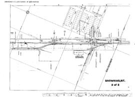
Plat Map of Great Northern Facilities at Browning, Montana, 1940
Part of Timothy Miller Collection
Plat Map of Great Northern facilities at Browning, Montana, January 1, 1940, Sheet Number 1, Line Segment 36, showing the Pacific Junction-Sandpoint Junction line.